Monday, January 23, 2006
The Colorado River
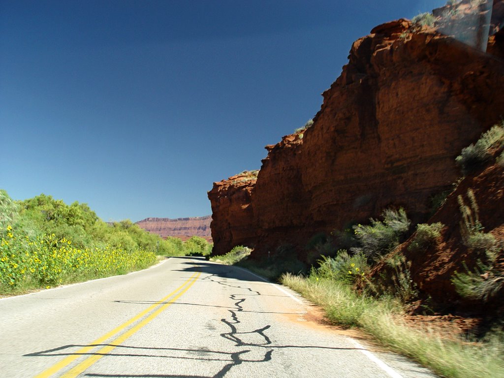
 After our brunch at Eklectica in Moab, we set out on Highway 128, which travels northeast right next to the Colorado River. It is a winding, picturesque road with towering red-black cliffs and plateaus on either side. The road runs along the south shore. There are lush green trees and grasses along the river’s edge, and we come across a campground near the Big Bend area.
As we drive along, we see a place where we can walk down to the river. We stop the car in a parking lot and walk down to a light-colored sandy, gravely beach spot. It’s very pretty with green trees to the right. There are some people
 lounging there with their picnic. Some yellow plastic rafts drift by, sliding to the left. In these two rafts, along with the people, are three dogs! At first, I think the people are going to paddle up to the beach, which seems to excite the dogs very much. I’m not quite sure why, but the people change their minds and row away instead. Poor doggies!
We continue with our trip. All along the road, side canyons, wide and narrow, twist down to the river. They are jagged and quirky, filled with spires and chunky boulders. After a while, the land flattens out a bit. Somewhere in this stretch,
 we pass at least two very elegant and expensive-looking dude ranches. One has extensive white-railed paddocks for horses. The ranches have elaborate gates and plantings near the road. Very fancy-schmansy!
We leave the ranches behind. Off in the distance to the east, we see some unusual spiky rock pillars. They are thin, red sheets of rock-wall jutting out from a monument plateau. We take a side road that leads up to their base. These are the Fisher Towers, which contain many hiking trails. The afternoon is very hot, so we just stop the car near some other tourists to take a quick
 look. As we are viewing the towers, Mark realizes that there are at least two people that have climbed up to the top of one of them! We have no idea how they got up there, or, better yet, how they are going to get down! If you look very closely at the middle of the fifth picture in this series, you will see them. Perhaps they are still there . . .
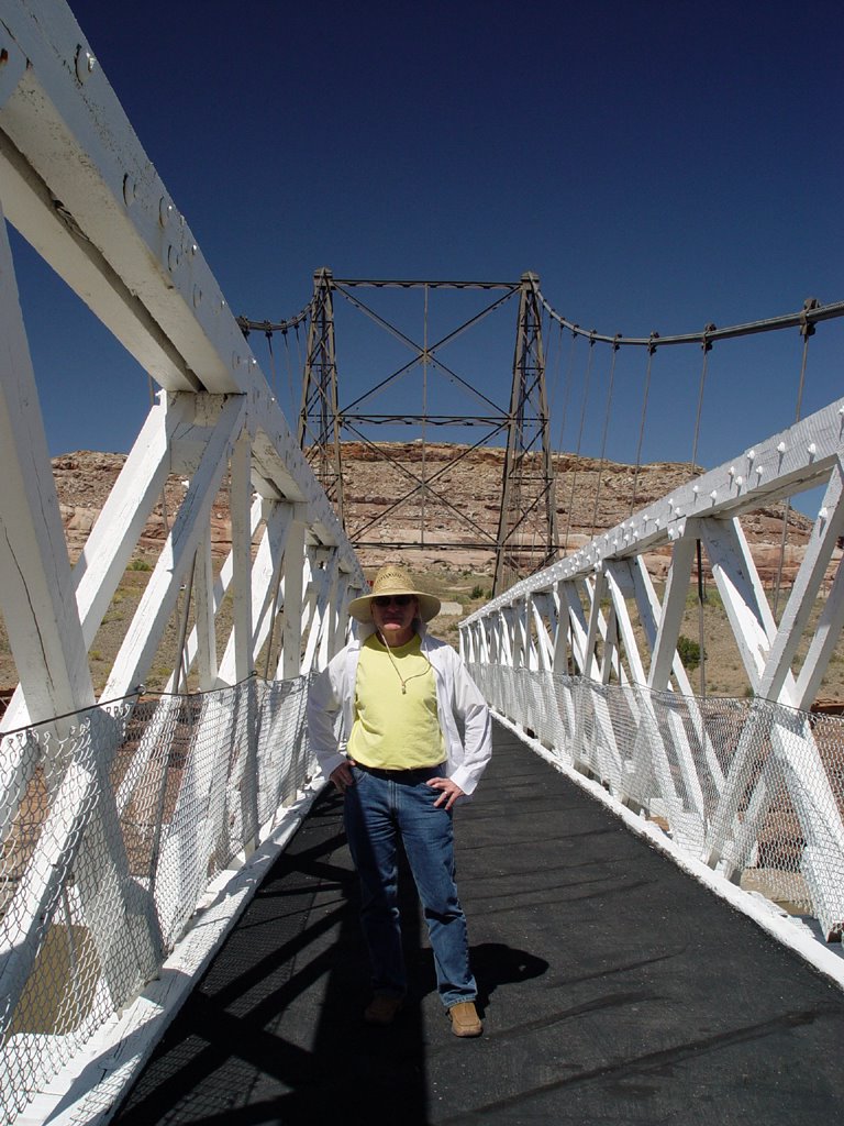
Highway 128 zigzags north after the Fisher Towers and passes over the Colorado River at Dewey. The original small suspension bridge still stands alongside the newer highway. The old tourist stores and picnic areas of Dewey are on
 the north side. The man that ran the stores is still there, in a house down the hill next to the river.
Rising up from the Colorado, we turn northwest and ride into . . . absolutely nothing! There are no houses, no plants. There is only the road. There are a few low, round hills and small ridges covered with short, light scrub and grass, but that is all. As far as the eye can see, there is nothing. This is called the Grand Valley, but it looks like a vast, flat plain.
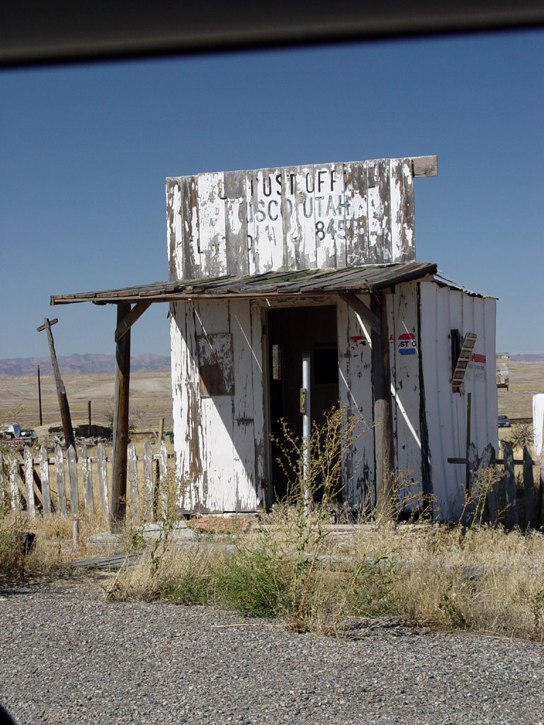
We turn northeast and come to the abandoned town of Cisco. The dilapidated, caved-in buildings sit in grassy, uncut fields—but wait! There are new cars here! People still live in this town.
We drive past Cisco northeast onto Highway 70 into the nothing again. Pink mountains topped with darkness rise off to the north, pink plateaus are in the southeast. Near the Colorado border, dark green junipers dot the pure blond
 grass, shining brightly in the sun. It makes for a strange landscape.
At the border, the junipers increase on low hills. Wide rolling valleys appear with low rocky plateaus of beige sparsely covered with juniper. Blond grass with light scrub and a few flowers cover the valley floors.
To the north, irrigated farms and a town sit in a vast, flat valley edged by pink and white mountains. At Mack, the road turns southeast to Loma. The road is bordered on the south by rounded, blond grass hills. At Loma, banded pink
 plateaus rise up in the south, with the wide Gunnison River near the road.
We come to Fruita. The plateau cliffs and canyons to the south are quite large and interesting, with blond hills at their base. To the northeast, a range of light pink and tan mountains looks like a gravel pit! Grand Junction is next, a big city with Sears and Walmart. We switch to Highway 50 here, and continue southeast.
Near Whitewater, a series of weird little yellow and white sand hills commence on the east side of
 the road. Large mountains dark with junipers stand behind them. This landscape continues all the way to Delta and Olathe. To the west, widely scattered houses, each with their own little enclave of items, are stationed on a wide, blond grass plain.
As we approach Delta, we notice a low, white cloud in the distance, going from west to east crossing the road. It is thick in the west, thin and hazy in the east. It looks like smoke. Delta has an odd landscape of tiny, gray rock canyons sunk into the ground here and there near the road.
Farm fields and trees cover the land to the west after we leave Delta. The east has some farms also, along with those weird yellow sand hills. We smell the smoke! Over the southwest horizon, there is a national forest. We assume that is where the fire is located.
We are at Olathe. Smoke covers the entire southern horizon.
 The countryside is fairly settled now, with farms, scattered trees and houses. The land is mostly flat with mountains still to the east. The mountains in front of us to the south are barely visible through the smoke.
We come to Montrose, where we will stop for the night. Tomorrow, we will turn east and head up into the mountains.

# posted by Unknown @ 3:52 PM 
![]()